


Kharga Oasis stands as the largest oasis in the Libyan Desert of Egypt, stretching approximately 160 kilometers long and between 20 to 80 kilometers wide. Located about 200 kilometers west of the Nile valley, this vast depression forms the southernmost of Egypt's five western oases. With an estimated population of 87,482 as of 2023, Kharga has developed into the most modernized of all western oases in Egypt.
The historical significance of Kharga extends far beyond its impressive geographical features. This remarkable area was submitted for consideration as a UNESCO World Heritage site in 2015, recognizing how Kharga played an important role in the historical evolution of Western and Central Africa. The oasis features a diverse natural environment punctuated by archaeological remains from various periods. Among these historical treasures stands the Temple of Hibis, the largest temple in the western oases and one of the few surviving structures built during the first Persian occupation of Egypt during the Twenty-seventh Dynasty (c.525-404 BC). During ancient times, Kharga served as an essential stopping point on caravan routes across the Western Desert, its springs, wells, and lake providing vital drinking water for travelers.

Kharga Oasis has been a crucial crossroads for ancient trade routes, connecting Egypt with regions to the south and west. It has a rich history dating back to prehistoric times and has been inhabited by various civilizations, including ancient Egyptians, Romans, and early Christians.
Geography and Climate of Kharga Oasis
Location in the Western Desert of Egypt
The Kharga Oasis occupies a depression in southwestern Egypt, positioned between longitudes 30°27″ and 30°47″ E and latitudes 22°30′16″ and 26°00′00″ N. Situated approximately 560 kilometers southwest of Cairo and about 200 kilometers west of the Nile Valley, this elongated depression extends for about 180 kilometers north-south with a width varying between 15-30 kilometers. The oasis encompasses approximately 22,000 square kilometers surrounded by parched desert terrains.
Topographically, the depression exhibits significant elevation variations, with the lowest point nearly at sea level while the highest reaches 400 meters above. The area sits on an anticline with a main axis extending from north to south, coinciding with major geological fault lines. Notably, the mineralogy of Kharga's arable soils resembles that of Nile silt, indicating an ancient connection with the Nile River.
Hot desert climate and seasonal extremes
According to the Köppen-Geiger climate classification system, Kharga possesses a BWh climate type (hot desert climate) characterized by extremely hot summers and mild winters with cool nights. Summer temperatures frequently exceed 42°C (108°F), with record highs reaching an extraordinary 50.3°C (122.5°F). Conversely, winter nights can be surprisingly cold, with temperatures occasionally dropping to 0°C (32°F).
Rainfall is remarkably sparse, averaging less than 1 mm annually, with many consecutive years possibly remaining completely rainless. The average relative humidity hovers around 37.9% throughout the year, peaking at 52% in January and dropping to 27% in May. Kharga experiences approximately 3,977 hours of sunshine annually, with June receiving about 12.2 hours of daily sunlight.
Natural vegetation and water sources
Seven distinct vegetation types flourish within Kharga Oasis, forming concentric zones from inner agricultural areas to outer desert regions. The dominant vegetation includes Alhagi graecorum, often associated with Stipagrostis scoparia, Calotropis procera, and Tamarix nilotica. In the southernmost area of Baris town, Balanites aegyptiaca (heglig) and Hyphaene thebaica (dom palm) grow in thickets among dunes.
The Nubian Sandstone Aquifer System (NSAS) provides the primary water source, covering more than 2 million square kilometers across Egypt, Libya, Sudan, and Chad. This fossil groundwater sustains vegetation and agriculture through natural drainage into Kharga soils. Several hundred deep artesian wells, some dating back to Pharaonic and Roman times, supply irrigation water, making possible the cultivation of date palms, olives, citrus fruits, and various vegetables.

Kharga Oasis has a hot desert climate with extremely hot summers and mild winters. Summer temperatures can exceed 42°C (108°F), while winter nights can occasionally drop to 0°C (32°F). Rainfall is extremely rare, averaging less than 1 mm annually.
Kharga Oasis is located in southwestern Egypt, approximately 560 kilometers southwest of Cairo and 200 kilometers west of the Nile Valley. It's the southernmost of Egypt's five western oases, stretching about 160 kilometers north-south.
Ancient History and Early Civilizations
Prehistoric settlements and lake systems
Archaeological evidence reveals human presence in Kharga Oasis dating back to the Upper Paleolithic period, approximately 40,000-50,000 years ago. Initially, hunter-gatherer groups settled near paleolakes and springs, utilizing stone tools in what was then a considerably wetter environment. Between 10,000-12,000 years BP, a large lake covered most of the depression, with Paleolithic sites located primarily around its edges.
As climate patterns shifted and the lake gradually shrank around 7,000 BC, populations moved to lower elevations, establishing more structured Neolithic settlements along ancient drainage systems. The Middle Holocene epoch (7300-8000 BP) witnessed a phase of pastoralism influenced by the Near East.
Pharaonic-era agricultural activity
The Old Kingdom period (2700-2200 BC) marked Kharga's integration into Egypt's broader economic network. The oasis became a vital endpoint for desert trade routes, primarily the Darb el-Arba'īn. This ancient caravan route connected the Al-Fashir area of Sudan to Asyut in Egypt, passing through Kharga.
Kharga's strategic position was recognized as early as the Old Kingdom, when the "Oasis Route" mentioned by officer Harkhuf served as an alternative to problematic portions of the Nile Valley. By the 12th dynasty (1786-1665 BC), the oasis had developed into an important transit point for desert caravans.
The role of Kharga in the New Kingdom
During the New Kingdom (1550-1070 BC), Kharga flourished as both an administrative center and a strategic frontier post. Recent investigations near Qasr al-Ghweita uncovered evidence of agricultural activities dating to this period, possibly related to wine production that Kharga was known to export.
The oasis thrived particularly during the 13th dynasty, serving as a refuge for Egyptian Christians during Roman rule. Archaeological findings reveal numerous monumental structures and ruins dating from the Middle Kingdom (2134-1569 BC) through the New Kingdom period. Kharga maintained its critical role as the southwestern portal of Egypt, facilitating connections between Egypt and southern Africa.

Customize Your Dream Vacation!
Get in touch with our local experts for an unforgettable journey.
Plan Your TripRoman and Christian Influence in Kharga
The Roman period marked a pivotal chapter in Kharga's history, transforming it into a strategic frontier outpost and religious center. Following Egypt's annexation, Roman authorities established extensive military and civilian infrastructure throughout the region.
Construction of Roman forts and settlements
Romans built an impressive chain of fortresses along Kharga Oasis to protect the vital Darb El Arba'īn trade route. These structures varied in size and function, ranging from small outposts to large fortified settlements with cultivation areas. Most notably, the legionary fortress of al-Deir was constructed at the end of the third century AD at the beginning of one of the shortest tracks leading to the Nile Valley. All fortifications were constructed primarily of mud bricks, though some contained small stone temples with wall inscriptions.
The Darb El Arba'īn trade route
This ancient caravan route, meaning "the forty-day road," connected the Al-Fashir area of Sudan to Asyut in Egypt. At least 700 years old, it likely operated from as early as Egypt's Old Kingdom. Merchants transported gold, ivory, spices, wheat, animals, and plants via this network. The journey across approximately 1,800 km typically took closer to 60 days despite its name.
Spread of Christianity and the Bagawat cemetery
As Christianity spread through Egypt, Kharga became an important religious center. The Bagawat necropolis, functioning from the 3rd to 7th century AD, stands as one of the earliest and best-preserved Christian cemeteries in the ancient world. It contains 263 funerary chapels, with the Chapel of Exodus and Chapel of Peace featuring remarkably preserved frescoes of biblical scenes. The discovery of Coptic churches at Kharga demonstrates the region's transition from paganism to Christianity.
Temple of Hibis and its Persian origins
The Temple of Hibis, located about 2 kilometers north of modern Kharga, represents the largest and best-preserved temple in the oasis. Construction began during the 26th Dynasty under Pharaoh Psamtik II around 500 BC. Though Persian in origin, Darius I made significant contributions to its decoration. The temple was dedicated to a syncretism of two local forms of Amun: "Amun of Hibis" and "Amun-Ra of Karnak who dwells in Hibis".

The Darb El Arba'īn, meaning "the forty-day road," is an ancient caravan route connecting Al-Fashir in Sudan to Asyut in Egypt. At least 700 years old, it likely operated from Egypt's Old Kingdom period. Merchants transported gold, ivory, spices, wheat, and other goods along this 1,800 km route.
The Temple of Hibis is the largest and best-preserved temple in the western oases. Construction began around 500 BC under Pharaoh Psamtik II, with significant contributions from Persian king Darius I. It was dedicated to "Amun of Hibis" and "Amun-Ra of Karnak who dwells in Hibis."
Archeological and Cultural Significance
Archaeological discoveries throughout Kharga Oasis reveal its extraordinary historical significance across millennia. The oasis has been nominated for UNESCO World Heritage status, recognizing its exceptional cultural and natural value.
Key archeological sites in Kharga Oasis
Excavations by the Metropolitan Museum of Art between 1907 and 1931 uncovered numerous significant sites. Among these, Ain Umm Dabadib features one of the Western Desert's most impressive Roman fortresses, complete with underground aqueducts and residential quarters. Prehistoric petroglyphs discovered throughout the region provide crucial evidence of climate change progression and human adaptation. The recent discovery of two Coptic churches with service buildings demonstrates the region's religious evolution.
The meteorite dagger and its connection to Kharga
Perhaps the most fascinating archaeological connection is King Tutankhamun's iron dagger. Scientific analysis using X-ray fluorescence spectrometry confirmed the blade contains high percentages of nickel and cobalt consistent with meteoritic origin. Researchers identified a meteorite found in the Kharga Oasis region as the only possible source material matching these specific metal compositions. This remarkable artifact demonstrates how ancient Egyptians valued celestial iron—considered approximately 80 times more valuable than gold.
Cultural heritage and historical continuity
Kharga's archaeological record shows remarkable cultural continuity from prehistoric to modern times. The oasis functioned as a crucial crossroads for ancient trade routes, enabling significant communication between disparate regions. Rock art throughout the area serves as a historical archive, documenting paleoclimatic variations and corresponding human adaptations.

Key archeological sites in Kharga Oasis include the Temple of Hibis, the largest and best-preserved temple in the western oases, the Bagawat necropolis with its 263 funerary chapels, and the Roman fortress at Ain Umm Dabadib. Prehistoric petroglyphs and recently discovered Coptic churches also highlight the area's historical importance.
Kharga Oasis stands as a testament to human resilience and adaptation across millennia. First inhabited during the Upper Paleolithic period when the climate was considerably wetter, Kharga witnessed the rise and fall of numerous civilizations. The strategic importance became particularly evident during the Pharaonic era when it served as a vital endpoint for the Darb el-Arba'īn trade route.
Roman authorities transformed the region into a frontier outpost, constructing an impressive chain of fortifications. Christianity flourished here, as evidenced by the remarkably preserved Bagawat necropolis with its 263 funerary chapels. The Temple of Hibis, dating to the Persian occupation period, remains the largest temple in the western oases.
The seven distinct vegetation types thriving today reflect settlement patterns dating back thousands of years. Though the climate has shifted toward extreme aridity, the Nubian Sandstone Aquifer System still sustains life, much as it did for ancient peoples. Kharga's UNESCO nomination recognizes its exceptional value as a living museum preserving evidence of prehistoric lake systems, pharaonic agricultural innovations, Roman military strategy, early Christian communities, and traditional desert adaptations—all within one remarkable geological depression in Egypt's Western Desert.
Despite its extremely arid climate, Kharga Oasis is sustained by the Nubian Sandstone Aquifer System. This underground water source allows for the growth of diverse vegetation and supports agriculture, including the cultivation of date palms, olives, and various fruits and vegetables.
Yes, Kharga Oasis was submitted for consideration as a UNESCO World Heritage site in 2015. This nomination recognizes its exceptional cultural and natural value, including its archeological remains, historical significance, and unique desert ecosystem.
The Bagawat necropolis, functioning from the 3rd to 7th century AD, is one of the earliest and best-preserved Christian cemeteries in the ancient world. It contains 263 funerary chapels, with the Chapel of Exodus and Chapel of Peace featuring remarkably preserved biblical frescoes.
Scientific analysis revealed that King Tutankhamun's iron dagger was made from meteoritic iron. A meteorite found in the Kharga Oasis region was identified as the only possible source matching the blade's specific nickel and cobalt composition, demonstrating ancient Egyptians' use of celestial materials.
As of 2023, Kharga Oasis has an estimated population of 87,482, making it the most populous and modernized of Egypt's western oases. The area has developed significantly while preserving its rich archaeological heritage.
Archaeological evidence reveals human presence in Kharga dating back to the Upper Paleolithic period, approximately 40,000-50,000 years ago. Early hunter-gatherer groups settled near paleolakes when the climate was considerably wetter, with a large lake covering most of the depression between 10,000-12,000 years BP.


As a UK passport holder, you'll discover that obtaining an Egyptian visa is a straightforward process, with multiple options designed to accommodate various travel purposes and durations.

El Fayoum, located one hour south of Cairo, is considered one of Egypt's most peaceful places and one of the most greenish oases in Egypt's desert

Bahariya is one of the more appealing of the desert circuit oasis, and it's also the easiest to access, being just 365 kilometers from Cairo.

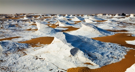
Farafra Oasis showcases the White Desert's dramatic chalk formations, therapeutic hot springs, and volcanic Black Desert. This remote Egyptian oasis, 627 km from Cairo, offers authentic Bedouin culture and stunning desert landscapes.

Dakhla Oasis spans 2,000 km² in Egypt's Western Desert, 350 km from the Nile. This UNESCO-listed site showcases Pharaonic heritage and traditional communities with 75,000 residents.

Kharga Oasis, Egypt's largest desert oasis, spans 160 km west of the Nile. This UNESCO nominee features the Temple of Hibis and preserves ancient caravan route heritage as the most modernized western oasis with 87,482 residents.


Siwa Oasis is a lush desert oasis below sea level, known for its natural springs, palm groves, ancient oracle, and preserved Berber culture.

Egypt’s Black Desert is a striking natural wonder marked by black volcanic hills, basalt formations, and surreal landscapes shaped by ancient volcanic activity and millions of years of erosion.

The White Desert is a protected natural area in Egypt near Farafra Oasis, known for its white limestone formations created by erosion over millions of years.

Crystal Mountain Egypt is a breathtaking natural landmark located between Bahariya and Farafra oases in the White Desert. Known as the “Jewel of the Desert,” it features clusters of sparkling quartz crystals formed over millions of years, making it one of the rarest geological formations in the world.
