


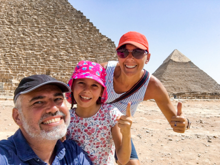
Farafra Oasis, spanning 980 km² in Egypt's Western Desert, is the second largest geological depression in Western Egypt yet remains the least populated oasis with 5,000 to 20,000 inhabitants. Historically known as "Ana Akhet" or "the land of the cow," honoring the deity Hathor, this remarkable cultural landscape features traditional Bedouin architecture and the stunning White Desert (Sahara el Beyda), designated as a national park since 2002 and located 45 km north of Farafra town. The region experiences dramatic seasonal variations, with summer temperatures averaging 33°C (91°F) and winter lows around 14°C (57°F).

Farafra Oasis is the second largest geological depression in Western Egypt, yet it has the smallest population among the western oases. It's known for its extraordinary natural attractions, including the White Desert National Park and unique chalk formations.
Geography and Climate of Farafra Oasis
The triangular-shaped Farafra depression lies precisely at latitude 27.06° north and longitude 27.97° east within Egypt's vast Western Desert. This unique geological formation occupies a strategic position approximately midway between the Dakhla Oasis and Bahariya Oasis. Situated 627 kilometers from Cairo and 370 kilometers southeast of the Mediterranean Sea, Farafra's isolation has contributed to its preserved natural state.
Location within Egypt's Western Desert
Farafra Oasis occupies a distinctive position within the New Valley Governorate, bordered by the imposing Great Sand Sea to the west. The oasis maintains connectivity with surrounding regions through a network of roads that link it to other Western Desert oases and the Nile Valley. Previously, travelers faced significant challenges reaching this remote location via unpaved routes, but recent infrastructure developments have improved accessibility considerably.
Size and topography of the Farafra depression
Covering an extensive area of 3,010 square kilometers (1,162 square miles), the Farafra depression represents the second largest geological depression in Western Egypt. Its terrain features more than 100 wells scattered throughout the region, many occurring naturally and supporting agricultural activities that sustain the local population.
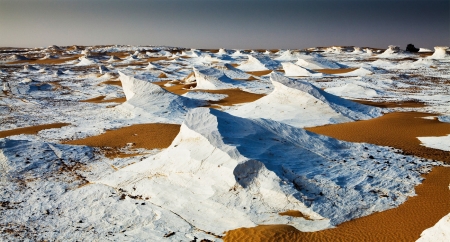
A primary geographical attraction of Farafra is the renowned White Desert (Sahara el Beyda), located 45 kilometers north of Farafra town. This striking landscape features massive chalk rock formations with distinctive white and cream coloration, sculpted over millennia by occasional sandstorms. The surrounding area also encompasses the Black Desert with its volcanic remnants, creating a dramatic contrast to the pale chalk formations and offering visitors a diverse geological experience.
Hot desert climate and seasonal variations
According to the Köppen-Geiger classification system, Farafra experiences a hot desert climate (BWh) characterized by extreme aridity and substantial temperature fluctuations between day and night. Summer months (June through August) see daytime temperatures soaring between 35°C to 45°C (95°F to 113°F), moderating to more comfortable 20°C-30°C (68°F-86°F) during nights.
During winter months (December through February), daytime temperatures average between 15°C to 22°C (59°F to 72°F), while nights can become surprisingly cool, dropping to around 5°C (41°F), particularly in January. Record temperature extremes range from a scorching 47.8°C (118.0°F) to a chilling -3.3°C (26.1°F). Notably, precipitation remains virtually nonexistent throughout the year, with merely 2mm (0.1 inches) of annual rainfall, primarily concentrated in January and November.

The region boasts the White Desert with its striking chalk formations, the Black Desert with volcanic remnants, Crystal Mountain composed of barite and calcite, and several hot springs like Bir Sitta and Ain Bishay.
Despite its hot desert climate with extreme aridity and temperature fluctuations, Farafra has supported human habitation since prehistoric times. The oasis has over 100 wells that sustain agriculture, allowing for the cultivation of date palms, citrus, and other crops.
Historical Timeline of Farafra Egypt
Archaeological evidence reveals that Farafra has been inhabited continuously through various historical epochs, with human presence dating back to the late Pleistocene period. The region's rich historical tapestry unfolds across millennia, shaped by changing climatic conditions and successive civilizations.
Prehistoric habitation and early rainfall periods
The Farafra region experienced three distinct wet phases around 9000 BC, 6000 BC, and 4500 BC, transforming what is now desert into habitable land supporting human communities. Middle Stone Age artifacts discovered at the Hidden Valley Plateau indicate human activity approximately 100,000 years before present. The Middle Holocene humid phase (10,000-5,000 BP) supported savanna-like vegetation and facilitated Neolithic settlements throughout the region.
Between 7000-5000 BC, semi-sedentary communities constructed circular or oval stone huts near ancient lake basins. Their economy centered on herding domesticated goats (introduced around 6200-5600 BC) and utilizing wild grasses, especially sorghum, as evidenced in samples dated to 7600-7400 BP.
Middle Kingdom and Ptolemaic references
Farafra appears in Egyptian historical records at least since the Middle Kingdom (2055-1650 BC). Ancient Egyptians called it "Ana Akhet" or "the land of the cow," symbolizing fertility and honoring the goddess Hathor. Throughout history, it gained reputation as a remote location due to its isolation. Pharaoh Ramses II (1279-1213 BC) reportedly imported stones from Farafra for his temple constructions in Luxor. Later, during the Ptolemaic period, the region fell under the administration of the Oxyrhynchite nome (19th Upper Egyptian nome).
Roman and Coptic era developments
Romans valued Farafra for grain cultivation and left architectural remnants across the oasis, such as Qaser Al Farafra, the Farafra Palace, and numerous rock-cut tombs. The oasis became a sanctuary for Egyptian Copts fleeing persecution. Archaeological excavations have uncovered an early Coptic settlement featuring residential structures, churches, and a mural depicting religious scenes.
Arab conquest and trade route significance
Following the Arab conquest in 641 AD, Farafra oasis thrived economically. Trade routes between the oasis and Nile Valley flourished, with camel caravans transporting dates, olives, cloth, and tea. The earliest Islamic reference to Farafra appears in al-Yaqubi's 9th-century work Kitab al-buldan, describing it as inhabited by people of "all descents," highlighting its diverse population.

Farafra has a rich history dating back to prehistoric times. It was known to ancient Egyptians, served as a Roman administrative center, became a sanctuary for Coptic Christians, and later thrived as an important stop on Arab trade routes.
"Ana Akhet" translates to "the land of the cow" in ancient Egyptian. This name honored the goddess Hathor, who was often depicted as a cow and symbolized fertility. The name reflected the oasis's life-giving properties in the midst of the harsh desert.
Customize Your Dream Vacation!
Get in touch with our local experts for an unforgettable journey.
Plan Your TripNatural and Geological Features of Farafra Desert
The geological landscape surrounding Farafra Oasis showcases remarkable natural phenomena formed over millions of years of geological activity. These distinctive features include dramatic chalk formations, volcanic remnants, crystal deposits, and therapeutic springs that define the region's unique character.
The White Desert: chalk formations and fossil evidence
The White Desert, officially protected as a national park since 2002, spans approximately 300 square kilometers north of Farafra town. This otherworldly landscape features massive chalk rock formations sculpted through wind erosion over millennia, creating shapes resembling mushrooms, fingers, and abstract figures that capture visitors' imaginations. The most famous formation, "The Finger of God" or "Al Qubar," rises an impressive 20 meters high from the desert floor.
Essentially a former seabed, the area contains numerous marine fossils, shells, and remnants of ancient crustaceans, providing compelling evidence of its underwater origins millions of years ago. These fossils offer scientists valuable insights into the region's geological history and the dramatic environmental changes that have occurred over time.
The Black Desert and volcanic remnants
In stark contrast to the White Desert stands the Black Desert, a region of volcano-shaped mounds distributed along approximately 30 km between the White Desert and Bahariya Oasis. These distinctive formations, reaching impressive heights of 100 meters, consist primarily of dark basalt sills and iron quartzite. The volcanic hills on the outskirts reveal eruptions of dark volcanic dolerite dating back to the Jurassic period, approximately 180 million years ago.
Crystal Mountain and its barite composition
Crystal Mountain, located between Bahariya and Farafra oases, features a distinctive natural arch made not of quartz as commonly misreported, but actually of barite (BaSO₄) and calcite (CaCO₃). Studies confirm the crystals' hardness at approximately 3.0-3.5 on the Mohs scale, corresponding to barite and calcite rather than quartz. The formation process resembles that of desert roses, with crystals developing from hydrovolcanic solutions that penetrated cavities in the sedimentary layers.
Hot springs: Bir Sitta, Ain Bishay, and Abu Nus Lake
Farafra Oasis contains numerous therapeutic hot springs that provide relief from the harsh desert environment. Bir Sitta (Well 6), located 6 km west of Qasr Al Farafra, offers water with warm temperature and slight sulfur content, making it ideal for swimming and relaxation. Ain Bishay, a Roman-era spring situated 10 km southwest of Qasr Al Farafra, has evolved into an irrigated grove of date palms. Furthermore, Abu Nus Lake, situated 15 kilometers north of Farafra Oasis, offers relief from the desert heat while supporting various bird species.

Cultural Landscape and Human Settlement
Farafra Oasis represents a unique human settlement where traditional practices and modern developments coexist amidst the harsh desert environment.
Traditional mudbrick architecture and Bedouin quarters
The town of Farafra contains distinctive quarters featuring traditional architecture—simple, smooth, unadorned structures built entirely in mud color. This architectural style has been consciously preserved through local cultural pride and tourism support. The oasis houses approximately 5,000 inhabitants, primarily Bedouins who have inhabited this region for centuries, maintaining their cultural traditions and way of life.
Agricultural practices and water well systems
Throughout the oasis, more than 100 wells—many naturally occurring—sustain agricultural activities that transform parts of the arid landscape. These water sources have enabled the cultivation of groves featuring date palms, citrus, olive, apricot, and carob trees. Primary crops include cereals, dates, and vegetables that sustain the local population. Recently, the Desert Research Center successfully drilled two groundwater wells at depths of 720-750 meters, enhancing agricultural development potential.
Badr Museum and local artistic heritage
Constructed in traditional Farafroni style with clay bricks, Badr Museum showcases the extraordinary work of self-taught artist Badr Abdel Moghny. His unique creations—including sculptures, oil paintings, and watercolors—depict oasis life using locally sourced materials like sand, stone, and mud. The museum has become the town's primary cultural attraction, drawing visitors interested in authentic local artistry.
Religious and spiritual significance of the land
The White Desert contains formations locals call "the finger of god" or "Al Qubar"—a 20-meter-high rock formation considered spiritually significant by local communities. Historically, Islamic influence entered Farafra not through the Nile Valley but via North Africa, as documented in al-Yaqubi's 9th-century work, creating unique cultural connections.

Visitors can explore traditional Bedouin quarters with distinctive mudbrick architecture, visit the Badr Museum showcasing local artistic heritage, and experience the spiritual significance of natural formations like "the finger of god" in the White Desert.
Farafra Oasis demonstrates human adaptability across millennia, witnessing civilizations from prehistoric settlements to Roman and Arab periods. The White Desert's ancient seabed formations and Black Desert's 180-million-year-old volcanic mounds reflect deep geological history. Despite receiving only 2mm annual rainfall, hot springs and wells have sustained agriculture and settlement. The preservation of traditional architecture and Badr Museum's artistic heritage showcase Bedouin cultural resilience, making Farafra a microcosm of Egyptian desert history.
The best time to visit Farafra Oasis is during the cooler months from October to April, when daytime temperatures range from 15°C to 22°C (59°F to 72°F). Summer months (June-August) can be extremely hot with temperatures reaching 45°C (113°F), making outdoor exploration challenging.
Farafra Oasis is located approximately 627 kilometers from Cairo in Egypt's Western Desert. Visitors can reach it by road through improved infrastructure that connects it to other Western Desert oases and the Nile Valley. The journey typically takes 7-8 hours by car.
At the White Desert National Park, visitors can explore dramatic chalk rock formations sculpted by wind erosion, including the famous 20-meter-high "Finger of God" formation. The park is ideal for camping, photography, and observing unique geological features and marine fossils from the ancient seabed.
Despite the harsh desert climate, Farafra's over 100 wells support the cultivation of date palms, citrus fruits, olives, apricots, carob trees, cereals, dates, and various vegetables. These crops sustain the local Bedouin population.
Crystal Mountain is a natural arch located between Bahariya and Farafra oases. It's composed of barite and calcite crystals (not quartz as commonly believed) with a hardness of 3.0-3.5 on the Mohs scale. The crystals formed from hydrovolcanic solutions, similar to desert roses.
Yes, Farafra town offers basic accommodations including guesthouses and small hotels. Many visitors also enjoy camping experiences in the White Desert under the stars. It's advisable to book accommodations in advance, especially during peak tourist season.

As a UK passport holder, you'll discover that obtaining an Egyptian visa is a straightforward process, with multiple options designed to accommodate various travel purposes and durations.

El Fayoum, located one hour south of Cairo, is considered one of Egypt's most peaceful places and one of the most greenish oases in Egypt's desert

Bahariya is one of the more appealing of the desert circuit oasis, and it's also the easiest to access, being just 365 kilometers from Cairo.

Farafra Oasis showcases the White Desert's dramatic chalk formations, therapeutic hot springs, and volcanic Black Desert. This remote Egyptian oasis, 627 km from Cairo, offers authentic Bedouin culture and stunning desert landscapes.

Dakhla Oasis spans 2,000 km² in Egypt's Western Desert, 350 km from the Nile. This UNESCO-listed site showcases Pharaonic heritage and traditional communities with 75,000 residents.

Kharga Oasis, Egypt's largest desert oasis, spans 160 km west of the Nile. This UNESCO nominee features the Temple of Hibis and preserves ancient caravan route heritage as the most modernized western oasis with 87,482 residents.


Siwa Oasis is a lush desert oasis below sea level, known for its natural springs, palm groves, ancient oracle, and preserved Berber culture.

Egypt’s Black Desert is a striking natural wonder marked by black volcanic hills, basalt formations, and surreal landscapes shaped by ancient volcanic activity and millions of years of erosion.

The White Desert is a protected natural area in Egypt near Farafra Oasis, known for its white limestone formations created by erosion over millions of years.

Crystal Mountain Egypt is a breathtaking natural landmark located between Bahariya and Farafra oases in the White Desert. Known as the “Jewel of the Desert,” it features clusters of sparkling quartz crystals formed over millions of years, making it one of the rarest geological formations in the world.
